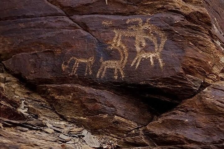
Archaeologists to document ancient petroglyphs in Iran’s Tuyserkan

TEHRAN – A team of archaeologists and cultural heritage experts has commenced work to study and document arrays of ancient petroglyphs scattered across the Tuyserkan county of Iran’s Hamedan province.
Tuyserkan’s tourism chief Es’haq Torkashvand on Wednesday announced the commencement of the process of studying and documenting the rock reliefs of the county, CHTN reported.
“There are numerous rock reliefs and petroglyphs in various parts of Tuyserkan county that bear witness to the ancient history of the region and indicate that these areas were once inhabited by humans.”
To safeguard that heritage, the process of studying and documenting these rock reliefs, aimed at identification, dating, preservation, and ultimately registering these artifacts, has begun by Tuyserkan’s department for cultural heritage, tourism, and handicrafts, the official explained.
He emphasized, “These petroglyphs hold significant historical values, and contrary to some beliefs, they have no connection to buried objects.”
Iran seeks UNESCO recognition for its millennia-old petroglyphs situated in Teymareh of Khomein county in Markazi province, and other ones located in the provinces of Isfahan and Lorestan, etc.
Teymareh, for example, is home to numerous petroglyphs that provide insights into past eras and cultures both by tools utilized for carving and themes being carved.
International experts Jan Brouwer and Gus van Veen have examined the Teymareh site, estimating its carvings were made 40,000-4,000 years ago. Prehistoric rock art provides insights into past eras and cultures as archaeologists classify the tools for the carvings by specific eras. Incising tools include flint, metal, or thigh-bones of hunted prey.
According to the available data, the first well-documented evidence of human habitation on the Iranian Plateau was found in several excavated caves and rock shelters, located mainly in the Zagros Mountains of western Iran, dating to the Middle Palaeolithic or Mousterian period (c. 100,000 BC).
From the Caspian in the northwest to Baluchestan in the southeast, the Iranian plateau extends for close to 2,000 km. The land encompasses the greater part of Iran, Afghanistan, and Pakistan west of the Indus River, containing some 3,700,000 square kilometers. Despite being called a “plateau”, it is far from flat but contains several mountain ranges, the highest peak being Damavand in the Alborz mountain range at 5610 m, and the Dasht-e Loot east of Kerman in Central Iran, falling below 300 m.
AFM
Leave a Comment